


It’s now early Monday morning, day three of this epic event, and I awoke to a dark house, as we were still without power. Living in this world of constant connectivity and electric powered amenities allows for a lifestyle that we take for granted, even breeding complacency and cockiness in our falsely perceived roles as masters of the universe. As of this moment, the word vulnerable and insignificant doesn’t even begin to describe the feeling of being trapped in your own neighborhood with all access roads cut off, no electricity, no Internet, and information coming only by radio, and others caught in the same predicament.
Starved for information, and needing some supplies we decided to reinvestigate the condition of the roads. After a quick visit to the main entrance revealed the main road was still under water, we slowly and carefully proceeded north on the only other main access road, 249, to Ashland City. It was a warm day, and the sun was now shining, giving the illusion for a brief moment that nothing was wrong outside of our development. This all changed when we saw some damage in the form of fallen trees, and scattered debris in the mud of some low-lying areas.
This particular road is not unlike many in middle Tennessee; rolling hills covered with thick forests, fields and pastures speckled with a 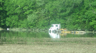 few random cows and horses, sparsely scattered houses, and a few small family farms here and there. After about 10 minutes of driving on this road, we came to an area that was void of housing for a few miles, and an eerie feeling set upon us as a large desolate lake appeared to our right, butting right up to the road. Our concern quickly escalated when it became obvious that this lake was brand-new, and probably a field a couple of days ago, as we could see the roof of a submerged tractor-trailer truck cab near the distant shore. No sooner had we spotted the sunken truck, when the now horrifying view through the windshield was that of this new lake completely surrounding the road, with the pavement disappearing about 100 feet in front of us. The straight flat highway of asphalt ahead looked like an ominous runway off the edge of the earth. With water on both sides of the road up to the painted white lines, I carefully executed a three-point turn on this death road to hell, and drove back to our home.
I went over and spoke to one of my neighbors about the road conditions we had just experienced, and he informed me there was one access road open. The road had some problems and required some detailed directions as there were many turns, but it was passable, so we decided to make a second attempt. Along the way we saw a large section of a hill that abutted 249 had ripped away, so we pulled over to make sure the road was safe. The stunning view over the guardrail was that of a hill that looked like it had a large bite taken out of it, with uprooted trees and brush strewn about like matchsticks more than 100 feet below. We carefully retreated to our car and cautiously proceeded past this weakened part of the road on the opposite side.
After a long drive through the winding maze of obscure back roads, we safely emerged near the Wal-Mart on Charlotte Pike. Our newly revised mission was to fill up our car with gas, purchase some ice, dry foods, and water, and find an Internet café. A phone call from our neighbor notified us that the electricity was finally back on, so we skipped the Internet café and returned home. It was now Monday early afternoon, and we were finally getting our first viewings of the totality of the destruction this historic flood was unleashing throughout the state on local news television.
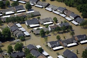 Some of the first images we saw reminded me of aerial pictures of damage caused by Hurricane Katrina; subdivisions containing hundreds of homes submerged under water almost to the rooftops, submerged vehicles stranded on roadways, mounds of debris, and cars stacked in piles like toys. We remained glued to the television throughout the day as new information and stories were developing exponentially. At some point in the afternoon, it was announced that the Opryland hotel was under 10 feet of water, and that 1500 guests had to be rescued. The entire area around the Opryland hotel including the Opry House, the Opry Mills Mall, and a parking lot in which our cars had been parked just 36 hours before were under 5 to 10 feet of water. Parts of downtown were being evacuated as water was now up to second avenue near Riverfront Park. Suburbs like Antioch, Bellevue, Old Hickory, and many others had homes, schools, and businesses
 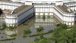 underwater, bridges and parts of roads washed away, and people being rescued from their homes and businesses by boats.
The flood was impacting areas far beyond the city limits, as the Cumberland River was well beyond flood stage in Clarksville. One newscaster made the frightening announcement that problems in a water treatment plant might cause for raw sewerage to be dumped into the Cumberland River there. Power outages were widespread, Interstates were experiencing closures due to flooding, and President Obama began the process of declaring disaster areas in over 50 counties spanning almost half the state.
Signs of being ill-prepared for a natural disaster of this magnitude started to become visible as video showed children and adults playing in floodwaters despite the occasional newscaster warning that the waters can contain sewerage, chemicals, and dangerous objects. Some of 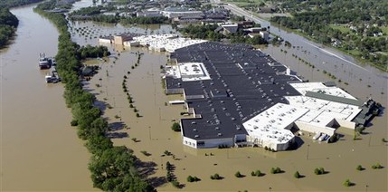 the flooding downtown was being caused by one businesses ill advised attempt to pump water from its basement, and barely mentioned were city officials requests for citizens to conserve water despite water treatment and purification facilities being down. Early predictions stated that the Cumberland river wood crest by 3 PM at 51.5 feet (flood stage is at 40), but these predictions kept getting pushed back into the evening hours. The local news stations, which had done a fair job of covering the event up to this point, became an embarrassing disappointment, when the 10 PM broadcasts showed rebroadcasts of events from earlier in the day, delivering no new news as to whether or not the waters were still rising or receding.
Physically and mentally drained, we decided to retire for the evening. Feeling relatively safe from the floodwaters on our hilltop haven, I can still barely comprehend all that’s happened over the past three days, and I still have feelings of anxiety and confusion. This disaster is far from over, and I’m sure that the tale of the great Tennessee flood of 2010 is just beginning.
One Response to The Great Tennessee Flood of 2010
Leave a Reply
You must be logged in to post a comment.
My heart goes out to all affected by this terrible flood. We have had flooding here in out neck of the woods but nothing compares to what Tenn. is going through.