Since first moving to Nashville in 2002 I have worked on several national tours, and for the most part, have had the luxury of traveling around on Prevost XLII tour buses, the luxury liners of touring. In my opinion, traveling by tour bus with a professional driver is, by far, the most comfortable and stress-free way to travel long distances with a group. Many musicians, past and present, are not so fortunate, and for some, “vanning it” is the only option. At a few different points during my touring years, I too have wound up in that category.
A couple of years into my life in Nashville, I played a handful of gigs with a regional cover rock band. On one particular weekend, we were hired to play at a biker party on top of Fredonia Mountain, a remote area far from civilization as we knew it, near the Tennessee-Alabama border (think Deliverance). Kelly and I left Nashville early afternoon driving in, you guessed it, a van (our trustworthy 2001 Dodge Caravan), loaded with my guitar equipment, a bag lunch, and some sleeping bags, as we were planning to sleep over after the show. The majority of the 130 mile drive was on Interstate 24, and we made it to our exit in just under two hours. The last 20 or so miles of the trip were on backroads, winding through hilly terrain, with a couple of small towns occasionally popping up out of nowhere. Keep in mind that this took place just prior to the era of affordable GPS technology, so we were relying on our printed out directions from Microsoft’s “Streets and Trips” to guide us.
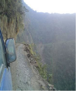
After driving around for about an hour, unable to find the access road to the mountain, we realized we were lost, and stopped at a convenience store to ask directions. There were two guys standing outside their pickup truck in the parking lot, and upon asking them how to get to Fredonia Mountain, they answered in a dialect of hick that was so far removed from the English language it might as well have been Klingon. At this point, now afraid to step outside of our van again, we realized we were on our own, and began to backtrack using our printed out directions. After taking a series of turns onto, what the directions labeled as “local roads”, we turned down one particular gravel road that, at first, seemed like the most logical access point to the mountain. As this gig was on top of a mountain, and we were driving on mountain roads, with the directions literally reflecting each new turn we took, we had no reason to think we were on the wrong track.  Any thoughts of such certainty quickly vanished when the gravel road upon which we were traveling emerged from the forest allowing us a horrifying view of reality. Kelly, who had been driving up to this point, stopped the van suddenly when we saw out of the driver’s side window, a sheer drop off about 3 feet to the left of the van. The view out of her window was that of treetops a couple hundred feet below us, and with the road being deeply rutted and on a downhill slope, we couldn’t back out of this predicament.
Already a mile or so down what was obviously an old logging trail, and no longer in cell phone coverage, we had no choice but to continue forward, in the hopes that this road might bring us to our destination. I got out and walked ahead of the van, slowly helping to guide Kelly through this dangerous section of road. After a few hundred feet, the drop-off section now passed, I hopped back in the van and we continued driving down this trail. Another mile or so of slow-going on this rough terrain and the dirt road became suddenly blocked by some fallen trees, making it obvious that we were going to have to turn around. Kelly, who was now in a near state of panic with dusk approaching, asked me to make the drive out. As there was no place to turnaround on this dead-end road into hell, I backed the van up for about a half mile to a spot that would allow a six-point turn. One more panic stricken ride past the lookout of death, and we emerged safely out of the forest.
We eventually made it to our gig (somewhat late), and as is it turned out, this logging trail brought us to within 5 miles of it. Unfortunately, the Microsoft provided directions, while bringing us to the base of the mountain, failed to show the dangers of these “local roads” and that the only safe access road was about 30 miles around the other side of the mountain. I wish we had a camera with us on that day, as our view out the van window of the valley of death was beyond words. The near perilous experience we lived through on that unforgettable day did teach us some valuable lessons we will never forget. Don’t ever completely rely on a Microsoft program to get you safely from point A to point B, always be suspicious of anything labeled “local roads”, avoid asking locals for directions whenever possible, and, always beware of the pitfalls of “vanning it”.


Leave a Reply
You must be logged in to post a comment.